Kuaokala & A Three-Corners Attempt
I wanted to try out a new trail - the Three-Corners from Kuaokala. I had no idea that it would be as long as it was. A big group decided to brave the recon with me - Adrian, Steve, Hai+Lu, Joe, Jeff, & Jiggles. Hai's intermittent GPS connection said we did 16-18 miles. He didn't load the topo, so we were guessing at paths the whole time.....
We combined the Kuaokala trail, the 4WD road to Peacock flats, the Mokuleia trail, to the "end of trail" sign of Kuaokala. You get a permit from the DLNR and drive up to the north-west corner of the island to the satellite tracking station road. We started hiking around 8:30am and didn't finish till 6:30pm, 15 minutes before sunset. It was a very long day.....
A topo map with our path: We did the Kuaokala trail before noon with some awesome views. We spent a bunch of time covering the 4WD road and wasted about 30 minutes on the red "paved road" that I thought went up to the ridgeline. Unfortunately, we were supposed to go down first..... Joe, Adrian, and Jiggles turned around at this point, and Steve, Hai+, Jeff and I made for the Corners. We managed to find the end of the Kuaokala trail after the hunter "shanty", but were out of time to do the corners. We ended up following a fence-line along the ridge for a little ways before coming back out onto the Mokuleia forest trail.
 A rough guess at our path on a google screenshot. Makua valley is the one on the left. We almost made it to see Makaha.....
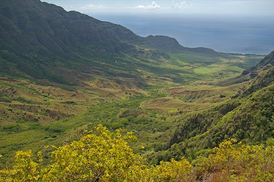
Makua valley in the evening from Kuaokala.
 My dirty feet.......
The north shore from along the 4WD road with Haleiwa harbor in the middle.
 North-shore wide....
 Intrepid hikers.
 The "end of the trail" that marks the beginning of the three-corners trail..... Hawaiian signs.
 The second (south) side of Makua valley.
 The northern part of the Waianae range.
 The beginning of the Kuaokala trail.
 Climbing a nub.
 Makua valley comes into view.
 The northern part of Makua valley

1 Comments:
pretty pretty pretty.........
:)
Post a Comment
<< Home